Before the late nineteenth century, timekeeping was essentially a local phenomenon. Each town would set clocks according to the motions of the Sun. Noon was defined as when the Sun would reach its maximum altitude above the horizon. A day was defined as the time it took the Sun to complete one day and night cycle and return to the same place in the sky. Cities and towns would assign individuals to calibrate sundials or clocks to these solar motions. This timepiece would serve as the official timekeeper, and citizens would set their watches and clocks accordingly.
The latter half of the nineteenth century was a time of increased human migration. In the United States and Canada, many people were moving west, and settlements in these areas began expanding rapidly. Railroads moved people and resources between the various cities and towns to support these new settlements. However, because of how local time was kept, the railroads experienced significant problems in constructing timetables for the various stops. The railroad companies tried to simplify timekeeping by establishing railroad time along sections of their routes. This procedure failed to simplify things, and by 1883, there were about 100 railroad times. Timetables could only become more efficient if the towns and cities adopted some standard method of keeping time based on broader geographical units.
Coordinating Time
In 1878, Canadian Sir Sanford Fleming proposed a system of worldwide time zones to simplify timekeeping across the Earth. Fleming proposed dividing the globe into 24 time zones, each 15° of longitude in width. Since the Earth rotates once every 24 hours on its axis and spans 360° of longitude, each hour of rotation represents 15° of longitude. Under Fleming's system, Canada and the United States would have five time zones over their geography.
Railroad companies in Canada and the United States began using Fleming's time zones in 1883. In 1884, an International Prime Meridian Conference was held in Washington, D.C., to adopt a standardized timekeeping method and determine the location of the Prime Meridian. Conference members agreed that the longitude of Greenwich, England, would become 0° longitude and established the 24 time zones relative to the Prime Meridian. It was also proposed that time on Earth be measured relative to the astronomical measurements at the Royal Observatory at Greenwich. This time standard was called Greenwich Mean Time (GMT).
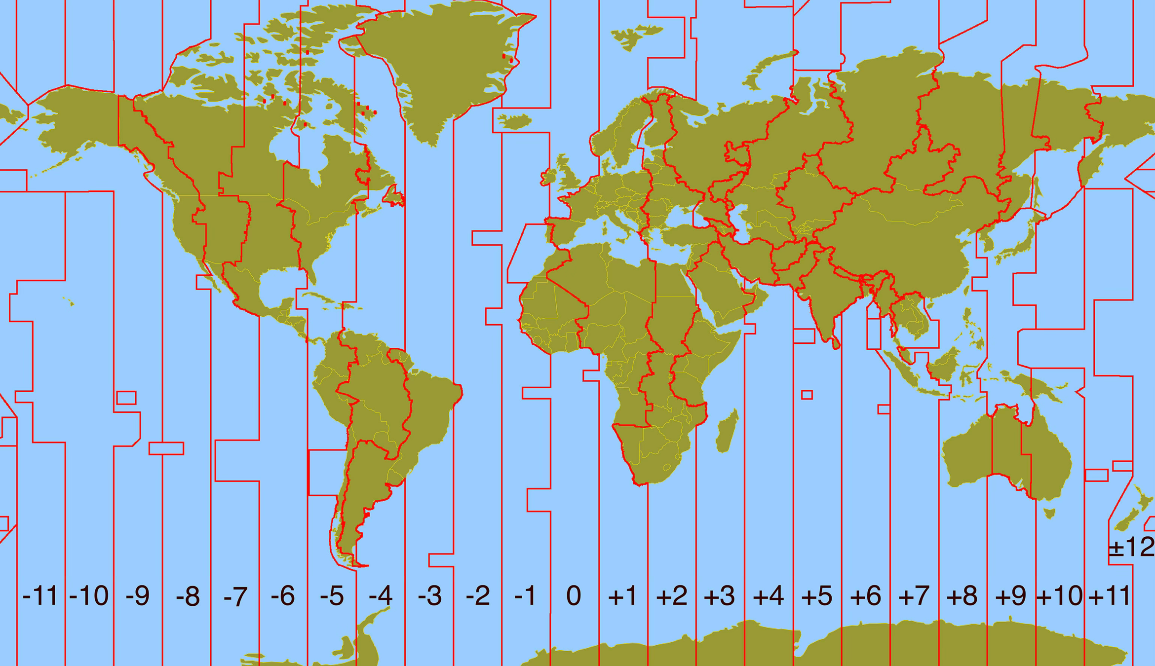
Today, many nations operate on variations of the time zones suggested by Sir Fleming. Figure 2.33 describes the various time zones currently used on Earth. This system measures time in multiple zones relative to the Coordinated Universal Time (UTC) standard at the Prime Meridian. Coordinated Universal Time became the worldwide standard legal time reference in 1972. UTC is determined from six primary atomic clocks coordinated by the International Bureau of Weights and Measures (BIPM) in France. The numbers at the bottom of Figure 2.33 indicate how long each zone is ahead (negative sign) or behind (positive sign) the Coordinated Universal Time standard. Note that the Prime Meridian is given a standardized time of zero. Also, note that national boundaries and political factors influence the shape of time zone boundaries. For example, China uses a single time zone (eight hours ahead of Coordinated Universal Time) instead of five different time zones.
International Date Line
Because time depends on longitude, there exists, at any moment, a meridian on the Earth that divides one day from another. The standardized location of this meridian is on the opposite side of the Prime Meridian. This meridian is appropriately named theInternational Date Line. Most of the International Date Line runs along the 180th meridian, except for a detour that separates Alaska and Siberia and two other bypasses that avoid the Aleutian Islands and a group of islands in the South Pacific (Figure 2.33). These detours have been created to circumvent the problem of having two different dates within the same country or island group.
FIGURE 2.33 The world’s modern standard time zones are measured relative to Coordinated Universal Time. Each time zone is about 15° wide. Some local variations occur to accommodate political boundaries. The numbers at the bottom of the map indicate how many hours each zone is ahead (negative sign) or behind (positive sign) of the time zone centered on the Prime Meridian. Some nations (for example, Australia and India) have offset their time zones by 30 minutes. Other nations, like China, have collapsed several time zones into a single zone across their country. Image Copyright: Michael Pidwirny.