Fog
Fog is simply a cloud of minute water droplets at or near ground level. Fog develops when the air near the Earth's surface is cooled enough to cause saturation or deposition (relative humidity equals 100%) of atmospheric water vapor. Some fogs can contain ice crystals (ice fog) because air temperatures are at or below 0°C (32°F) or a mixture of ice crystals and tiny water droplets. Meteorologists have a precise definition for determining whether fog exists. This definition suggests that fog occurs when the visibility in the atmosphere near Earth's surface falls below 1 kilometer (0.62 mi). Some of the foggiest places in North America include the Grand Banks off Newfoundland (Canada), Cape Disappointment, Washington, and Point Reyes, California.
A variety of processes can create fog. Radiation fog, or ground fog, is produced by near-surface cooling of the lower atmosphere due to longwave radiation emission (Figure 17.9). This type of fog is usually relatively shallow and develops in the evening, especially in autumn and winter. Shortly after sunrise, radiation fog dissipates due to absorption of solar radiation and the resulting surface heating. This heat causes the water droplets in the fog to evaporate back into the atmosphere.
Upslope fog is created when air flows over higher topography. When air rises over a topographic barrier, it cools adiabatically, forming upslope fog. This type of fog often forms on the windward slopes of hills or mountains.
Advection fog is generated when air flows over a surface with a different temperature. Warm-air advection can produce fog when warm air flows over a cold surface. The contact cooling associated with this process causes saturation in a relatively thin layer of air immediately above the ground surface. It can occur when warm air flows over ground covered with snow or ice.
Evaporation fog is a specific type of advection fog. It occurs when cold air advances over warm water or warm, moist land surfaces. In this situation, fog forms when water from the surface evaporates into the cold air and then saturates (Figure 17.10). This type of fog can also be called steam fog or sea smoke.
Frontal fog is a type of fog that is associated with weather fronts, particularly warm fronts. In this situation, rain descending into the colder air ahead of the warm front can increase the quantity of water vapor in the atmosphere through evaporation. The fog forms when the amount of water vapor in the air ahead of the front reaches saturation (relative humidity equals 100%).
Precipitation
We can define precipitation as any liquid or solid aqueous deposit that forms in a saturated atmosphere (relative humidity equals 100%) and falls from clouds to the ground surface. It is essential to recognize that most clouds do not produce precipitation. In many clouds, water droplets and ice crystals are too small to overcome the natural updrafts in the lower atmosphere. As a result, these tiny water droplets and ice crystals remain suspended in the atmosphere until they are converted back into vapor.
Water droplets and ice crystals can only fall to the Earth's surface if they grow to a size that can overcome updrafts. Conditions for growth can develop in clouds by way of two different processes. In clouds with temperatures above freezing, turbulent atmospheric mixing can cause droplets to grow through the processes of collision and coalescence. One initial condition, however, must be met for this process to begin. Droplet size in the cloud must be variable. This initial condition allows larger and heavier droplets to collide and coalesce with lighter, smaller droplets during downdraft periods. The average size of such cloud water droplets is about 0.02 mm (millimeters) (0.0008 in). If enough atmospheric mixing occurs, the larger droplets can expand up to 250 times and become heavy enough to fall to the Earth's surface.
The other mechanism of precipitation development involves clouds whose temperature is below freezing. Large ice crystals grow in these clouds due to the differences in vapor pressure between ice crystals and supercooled water droplets. Vapor pressure differences between ice and supercooled water cause a net migration of water vapor from water droplets to ice crystals. The ice crystals then absorb the water vapor from the surrounding air, depositing it on their surfaces. At the same time, the loss of vapor from the water droplets causes them to shrink. A necessary initial requirement for this process is the presence of both condensation nuclei and deposition nuclei. While deposition nuclei form ice crystals at temperatures just below 0°C (32°F), condensation nuclei can remain liquid (supercooled) to temperatures as low as -40°C (-40°F), depending on size. Because of this phenomenon, cold clouds can contain both ice crystals and supercooled water droplets. The relative proportions of these two particle types determine whether snow crystals grow to a mass that can overcome common atmospheric updrafts.
The following discussion describes the various types of precipitation that can form in the atmosphere. Rain is any liquid deposit that falls from the atmosphere to the surface and has a diameter greater than 0.5 mm (0.02 in). The maximum size of a raindrop is about 5 mm (0.2 in). Beyond this size, intermolecular cohesive forces become too weak to hold the mass of water together as a single drop. Drizzle is falling droplets of water in the atmosphere with a size between 0.2 and 0.5 mm (0.008 to 0.02 in) in diameter. This form of precipitation generally falls at a lower speed than rain from stratus and stratocumulus clouds.
Freezing rain occurs when falling liquid water droplets meet a surface with a temperature below 0°C (32°F). Upon contact with this surface, the rain quickly freezes. Another important condition required for freezing rain is that the atmosphere where rain develops must be above freezing. A situation in which warm air is found above cold air is called a temperature inversion (Figure 17.11). Temperature inversions are not the ordinary state of the lower atmosphere. Usually, air temperature decreases with increasing altitude in the troposphere. In the mid-latitudes, we often find temperature inversions developing along the moving front edge of a cold air mass, overtaking warmer air. This condition causes the less dense warm air to be pushed up and over the more dense cold air.
Ice pellets or sleet are transparent or translucent spheres of frozen water. They have a diameter smaller than 5 millimeters (0.2 in). This form of precipitation first develops as raindrops in a relatively warm atmosphere where the temperature is above freezing. These raindrops then descend into a colder lower layer of the atmosphere, where freezing temperatures occur. In this layer, the cold temperatures cause raindrops to freeze into ice pellets as they fall to the ground. Like freezing rain, an air temperature inversion is required to form ice pellets.
Snow is a type of precipitation common to the mid and high latitudes (Figure 17.12). Snow develops when water vapor becomes deposited (skipping the liquid phase) directly on a six-sided (hexagonal) deposition nucleus as solid crystals. This phenomenon occurs only when temperatures are below freezing. The unique form of snowflakes occurs because ice crystal growth is most rapid at the six points associated with the geometric shape of the deposition nuclei. These points are more directly exposed to the atmosphere, converting more water vapor into ice. Snow is usually generated by frontal lifting associated with mid-latitude cyclones. Snowfall can occur in the fall, winter, and spring when atmospheric temperatures typically drop below freezing. During a typical year, much of the ground surface of North America is covered with snow for several months (Figure 17.13).
Snow pellets or graupel are spherical white ice bits with a diameter of less than 5 mm (0.2 in). Snow pellets develop when supercooled droplets freeze onto the surface of falling snowflakes. Snow pellets usually only fall briefly when precipitation changes from ice pellets to snow.
Hailis a type of frozen precipitation that is more than 5 mm (0.2 in) in diameter (Figure 17.14). Maximum size is about 150 mm (15 cm or 5.9 in). Hailstones often have concentric shells of ice alternating between those with a white cloudy appearance and those that are clear. The cloudy white shells contain partially melted snowflakes that freeze onto the surface of the growing hailstone. The transparent shells develop when liquid water freezes to the hailstone's surface. Strong updrafts in mature thunderstorm clouds provide the mechanism for hail formation. These updrafts move hailstone embryos (often large frozen raindrops) upward through the storm cloud, where they meet with layers of ice crystals, snow, and supercooled rain (Figure 17.15). Each encounter causes the hailstone to grow larger as ice, snow, and rain accumulate on its surface. Hailstones can grow very large when they are carried upward by more than one updraft. When the hailstone becomes too heavy to be supported by updrafts, it begins falling under the influence of gravity. Descending hailstones can lose a significant amount of their mass because of melting as they meet the warm air found between the cloud base and the Earth's surface. Small hailstones often melt entirely before they reach the ground.
Measuring Precipitation
Precipitation has both direct and indirect effects on human well-being and economic activities. Too much or too little precipitation can significantly affect these factors and even lead to loss of human life. Consequently, precipitation is measured at thousands of weather stations and other locations worldwide.
Standard Rain Gauge
The standard rain gauge is the most common instrument for measuring rain and sometimes snow. This meteorological instrument was developed around the start of the 20th century, and it consists of a large funnel connected to a graduated measuring cylinder. Usually, the funnel and cylinder are housed in a much larger container (Figure 17.16). To make measurements more accurate, the funnel's cross-sectional area is often 10 times the cylinder's cross-sectional area. As a result, 1 mm of rainfall would magnify to 10 mm of water in the graduated measuring cylinder. Measurements from the standard rain gauge are typically made once or twice a day.
Tipping Bucket Gauge
The tipping bucket rain gauge consists of a large cylinder with a funnel located at its top for collecting precipitation (Figure 17.17). Precipitation is channeled to an opening at the bottom of the funnel that causes the water collected to fall into one of two small, joined buckets balanced in a seesaw fashion. After a certain amount of precipitation falls into a bucket, the seesaw tips to the other bucket, and an electrical response is transmitted to a recording device. Most of these recording devices have a pen mounted on an arm attached to a geared wheel that moves because of a clock mechanism. As the wheel rotates, the pen arm moves, producing a trace on mounted graph paper. Movements in the pen arm documented on the graph paper record the quantity and the time when precipitation fell. From the graph, one can determine rainfall intensity simply by calculating the amount of rain that fell for a particular unit of time. The tipping bucket rain gauge is not as accurate as the standard rain gauge because you need a specific threshold amount of rainfall to cause the bucket to tip.
Measuring Snowfall
Different devices and techniques are used to measure snowfall. Rain gauges are not used for measuring snowfall for several reasons. Measuring snowfall with rain gauges requires that the snow that falls in the funnel be melted so the water can accumulate in the graduated cylinder. This situation may not be possible on extremely cold days. On windy days, turbulence around the cylinder can reduce the amount of snow collected in the funnel. Another potential problem is that heavy snowfall can quickly overfill the funnel, causing excess snow to spill to the sides of the rain gauge.
A Nipher snow gauge is a Canadian-designed meteorological instrument specially constructed for collecting and accurately measuring snow (Figure 17.18). This instrument has two parts: a catchment cylinder and a funnel that reduces wind turbulence around the gauge opening. The total length of the snow gauge is about 0.5 meters (1.6 ft). Snow gauges are usually mounted on a pipe about 1.5 meters (5 ft) from ground level. The cylinder that collects fallen snow is removable and can be replaced with a spare when measurements are made. The accumulated snow is then melted in the cylinder and poured into a graduated measuring container.
Another simple technique for measuring snowfall is to measure the snow that accumulates on a flat platform using a measuring stick. This measured snow depth is then converted into an equivalent rain depth. Typically, a 10:1 ratio is used to make this conversion. For example, 10 cm of snow would equal 1 cm of rain. This method can sometimes be inaccurate because snow can vary widely in its water content. In cold “powder” snow, 30 cm of snow may be equal to only 1 cm of water (30:1 ratio), while wet snow, common on the East Coast of Canada and the United States, can have a ratio as low as 4:1.
Radar Systems
Advancements in technology have enabled the measurement of precipitation using Doppler radar systems. Radar systems operate by emitting a microwave pulse signal toward a desired target. If the signal intercepts an object, it or part of it will be reflected back and picked up by a receiving dish. When used for weather measurements, the returning signal strength is calibrated to precipitation quantity (Figure 17.19). Many Doppler radar weather systems have been installed throughout the United States and Canada over the last two decades. These systems produce an image identifying precipitation areas every 5 minutes. Radar systems cannot distinguish between rain and snow. The accuracy of precipitation estimates from radar systems is far lower than that of rain and snow gauge measurements. However, they provide valuable information on the spatial distribution of precipitation and on the possible paths that storm systems take.

FIGURE 17.9 Ground fog in East Frisia, Germany. Image Source: Wikipedia, photo by Matthias Süßen. This file is licensed under the Creative Commons Attribution-Share Alike 2.5 Generic license.
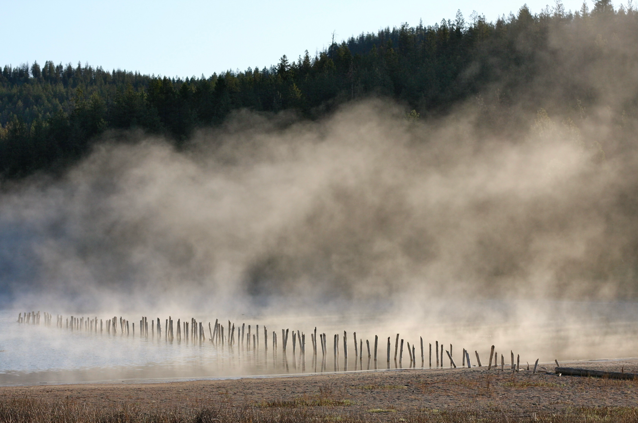
FIGURE 17.10 Evaporation fog forming over a small lake as cool air flows over the warm water. Image Copyright: Michael Pidwirny.

FIGURE 17.11 Typical temperature profile in the troposphere compared to a situation where a temperature inversion exists. The dotted lines in the two graphs show the change in air temperature with height. In a typical atmosphere, the temperature declines with increasing altitude. In an inversion atmosphere, temperature first increases with altitude to a specific level and then decreases with altitude beyond that point. In this illustration, precipitation forms as rain in the cloud because the air temperature is above 0°C at this height. As rain falls, it enters a portion of the atmosphere where temperatures are below 0°C (32°F). This situation would cause the rain to freeze on contact with the Earth’s surface or before it hits the ground. Image Copyright: Michael Pidwirny.
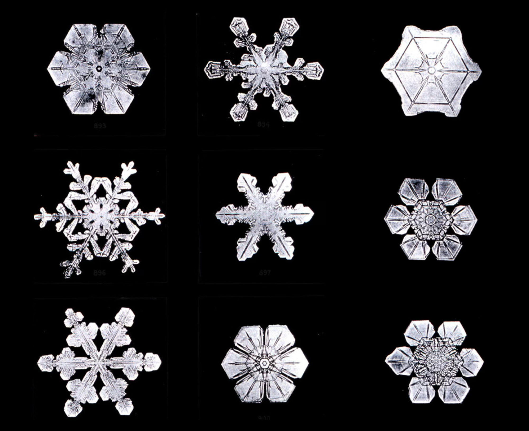
FIGURE 17.12 Close-up photographs of nine different snowflakes. Modified Image Source: Wikipedia, photo by Wilson Bentley.

FIGURE 17.13 The extent of North American ground snow coverage on February 2-9, 2002. Image Source: NASA - Earth Observatory.
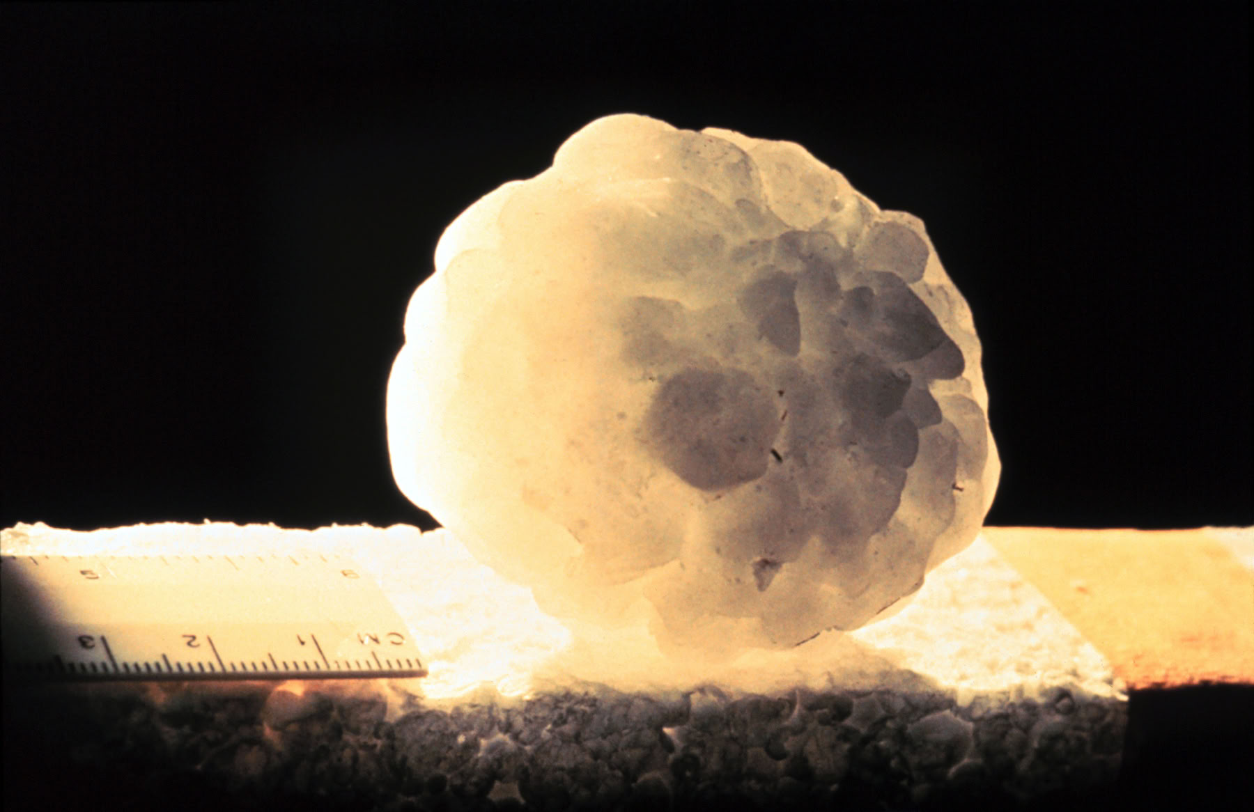
FIGURE 17.14 A large hailstone measuring six centimeters (2.4 inches) in diameter. Image Source: NOAA - Photo Library Website.

FIGURE 17.15 Typical hailstone growth path through a thunderstorm cloud. Hailstones add most of their mass during updrafts. Image Copyright: Michael Pidwirny.

FIGURE 17.16 The standard rain gauge. Image Source: Wikimedia Commons, photo by Bidgee. This image is licensed under the Creative Commons Attribution 3.0 Unported license.
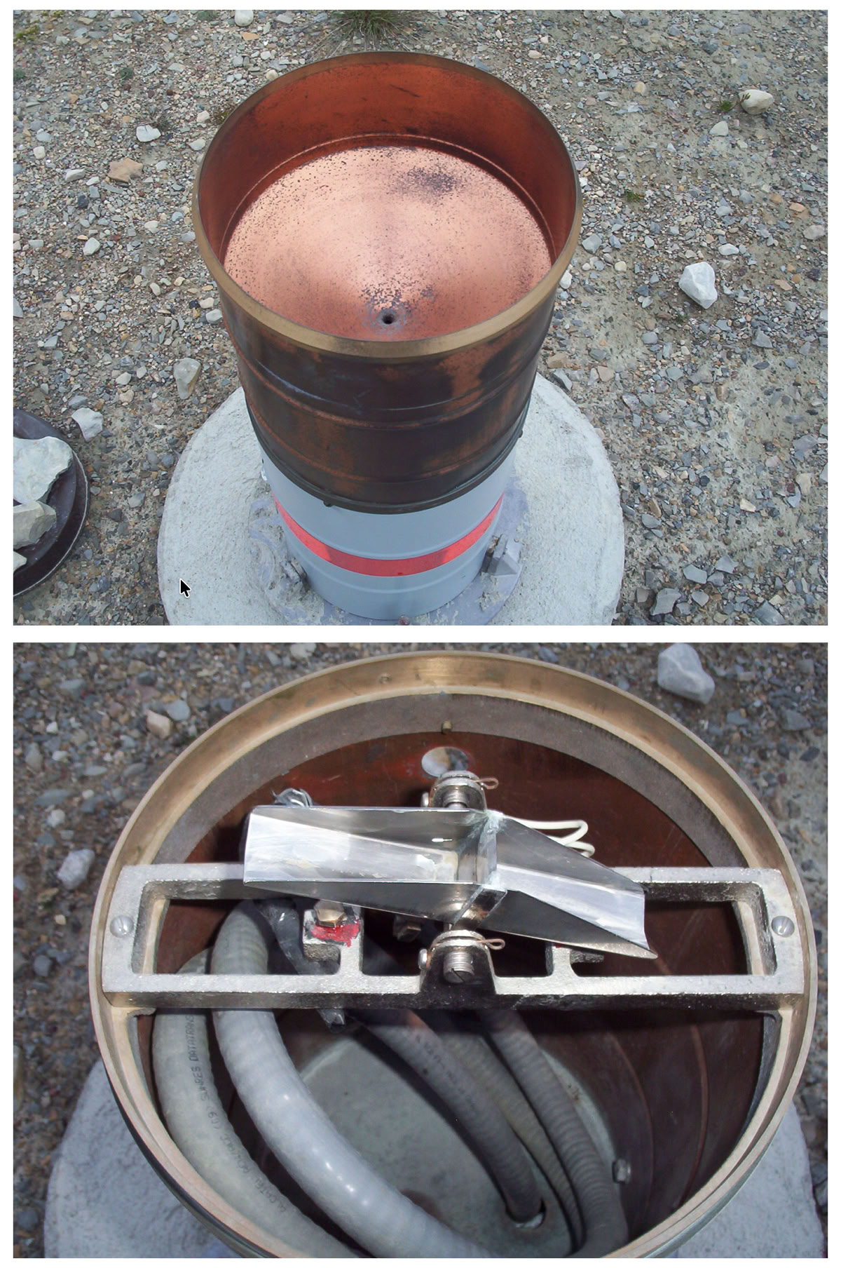
FIGURE 17.17 The tipping bucket rain gauge. The top photo shows the instrument's exterior and the funnel at its top. The bottom photo shows the tipping buckets inside the device. Image Source: Wikipedia1 and Wikipedia2.

FIGURE 17.18 The Nipher snow gauge. The cone-shaped top of this instrument minimizes wind-induced undercatch of falling snow. Image Source: Wikimedia Commons.
