
Condensation or deposition of water above the Earth's surface creates clouds. Clouds develop in any saturated air mass (relative humidity becomes 100%). Saturation can occur through atmospheric mechanisms that cool an air mass to its dew point or frost point. The following mechanisms or processes can achieve this outcome, causing clouds to develop.
Orographic uplift occurs when air is forced to rise because of the physical presence of elevated land. As the parcel rises, it cools by adiabatic expansion at approximately 10°C per 1000 meters (5.5°F per 1000 ft) until saturation. The development of clouds and resulting heavy precipitation along the West Coast of Canada and the United States is mainly due to this process.
Convectional lifting is associated with surface heating of the air at the ground surface. If enough heat is added, the air becomes warmer and lighter than the surrounding air, and, like a hot-air balloon, it begins to rise, expand, and cool. When sufficient cooling has taken place, saturation occurs, forming clouds. This process is active in the interiors of continents and near the equator, forming cumulus clouds and/or cumulonimbus clouds (thunderstorms). The rain associated with thunderstorm development is delivered in large amounts over short periods in extremely localized areas.
Convergence or frontal lifting takes place when two masses of air come together. The two air masses usually have different temperature and moisture characteristics. One air mass is typically warm and moist, while the other is cold and dry. The leading edge of the latter air mass acts as an inclined wall or front, causing the moist warm air to be lifted. Of course, the lifting cools the warm, moist air mass through expansion, leading to saturation. This cloud formation mechanism is common in mid-latitudes, where cyclones form along the polar front and near the equator, where the trade winds meet at the Intertropical Convergence Zone.
Radiative cooling occurs when the Sun no longer supplies the ground and overlies air with energy derived from solar insolation (e.g., night). Instead, the Earth's surface now begins to lose energy as longwave radiation cools the ground and the air above it. The clouds that result from this type of cooling form surface fog.
Obviously, these causes of cloud development do not always act independently in specific locations and areas on our planet. The process may involve combinations of all four types, such as when convection and orographic uplift cause summer afternoon cloud development and showers in the mountains.
The following two images (Figures 17.7 and 17.8) show the average global cloud coverage for January and July, based on 14 years of observations from NASA's Aqua Satellite. From these images, one can see the effects of convergence, frontal lifting, and orographic uplift in enhancing cloud cover over specific areas of the Earth.
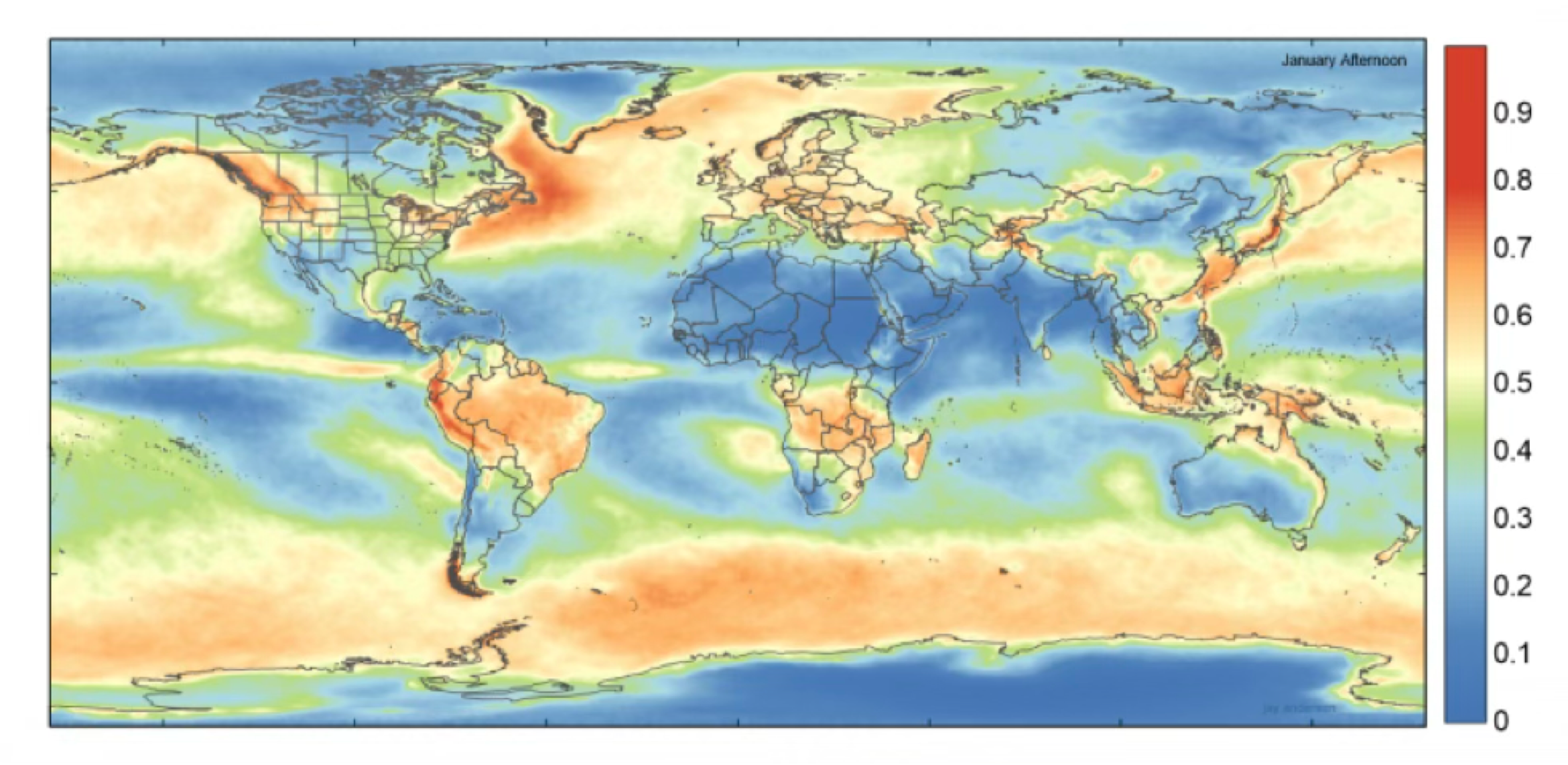
FIGURE 17.7 Average percent January afternoon cloud cover determined by NASA’s Aqua Satellite observations: July 2002-2015. The highest levels of cloud cover occur over the mid-latitude cyclone storm tracks of both hemispheres and the Intertropical Convergence Zone over land surfaces. The lowest values occur over subtropical deserts, subtropical ocean subsidence regions, and the South and North Polar regions. Image Source: Jay Anderson and Jennifer West, https://eclipsophile.com/global-cloud-cover/.
FIGURE 17.8 Average percent July afternoon cloud cover as determined from NASA’s Aqua Satellite observations: July 2002-2015. The highest levels of cloud cover occur over the mid-latitude cyclone storm tracks of both hemispheres, the Intertropical Convergence Zone over land surfaces, and the Indian Monsoon region (orographic uplift). The lowest values occur over subtropical deserts, subtropical ocean subsidence regions, and the South and North Polar regions. Image Source: Jay Anderson and Jennifer West, https://eclipsophile.com/global-cloud-cover/.